Training Programs with KukerRanken using Pix4D_Leica_drones

KukerRanken Training

Brady Reich teaching Pix4D for Construction
We are able to train large or small groups

KukerRanken offers training in Hardware, Software, and application-specific best practices. KR believes an informed customer is more productive. In addition to our 24/7 support phone/text lines, we offer training for individuals or groups, ensuring cost-effective, optimal workflows for any survey or AEC (Archetectural, Engineering, Construction) organization. 
KukerRanken is dedicated to customer service, and without understanding equipment, software, workflows, and best practices, our customers may not be working at optimal efficiency.

Training may take place on-site, online, or at one of our KukerRanken store locations.  Software-based training is typically provided on-line, while we remain flexible and are able to visit company offices, jobsites, or local locations. Our Mountlake Terrace store offers multi-desk classrooms, projector, large screen televisions, and a broad assortment of equipment and specialists to ensure an effective, efficient, and ensured understanding of equipment, related software/hardware/workflows for our customers.


A group of people standing in front of a small drone.
We are an authorized Microdrones trainer for both LiDAR flight and post-processing, as well as their Mapper Photogrammetry product.

HARDWARE TRAINING:

  • Robotic Total Stations
  • Data Collectors
  • GPS systems
  • High Definition Scanning
  • DTResearch (RTK/LiDAR tablet
  • Emlid products for UAS
  •  

UAS (Drone) TRAINING:

  • Part 107 certification
    • Online
    • In-person
  • Risk Mitigation
  • Flight Training
  • Automated Flight Instruction
  • Equipment Maintenance
  • Best-Practices
  • Program Stand-Up

SOFTWARE TRAINING FOR SURVEY and AEC

  • Leica Infinity
  • iCON
  • 3DR/Cyclone


SOFTWARE TRAINING FOR UAS

  • Mission Planning
  • Pix4D
    • Mapper
    • Survey
    • Matic
  • AirData
  • Autel Explorer
  • Evidence Recorder

KukerRanken is partnered with Sundance Media Group for UAS and Risk Mitigation training. 

We have training available at all stores, with specialty/focused training at our Mountlake Terrace, WA, and Las Vegas, NV locations

A Deep Insider’s Look at a Rugged Terrain Mission to Investigate a Helicopter Crash with Drones

A Deep Insider’s Look at a Rugged Terrain Mission to Investigate a Helicopter Crash with Drones

Crash site investigation with drones has emerged as a leading application for unmanned systems in public safety.  Gathering data that can be used by investigators in a courtroom, however, requires careful mission planning.  Here, sUAS expert and industry figure Douglas Spotted Eagle of  KukerRanken provides a detailed insider’s view of a helicopter crash site investigation.

Unmanned aircraft have become proven assets during investigations, offering not only the ability to reconstruct a scene. When a high ground sampling distance (GSD) is used, the data may be deeply examined, allowing investigators to find evidence that may have not been seen for various reasons during a site walk-through.

Recently, David Martel, Brady Reisch and I were called upon to assist in multiple investigations where debris was scattered over a large area, and investigators could not safely traverse the areas where high speed impacts may have spread evidence over large rocky, uneven areas. In this particular case, a EuroStar 350  aircraft may have experienced a cable wrap around the tail rotor and boom, potentially pulling the tail boom toward the nose of the aircraft, causing a high speed rotation of the hull prior to impact. Debris was spread over a relatively contained area, with some evidence unfound.

crash site investigation with drones

Per the FAA investigators;

“The helicopter was on its right side in mountainous densely forested desert terrain at an elevation of 6,741 ft mean sea level (MSL). The steel long line cable impacted the main rotor blades and was also entangled in the separated tail rotor. The tail rotor with one blade attached was 21 ft. from the main wreckage. Approximately 30 ft. of long line and one tail rotor blade were not located. The vertical stabilizer was 365 ft. from the main wreckage.”

With a missing tail rotor blade and the missing long line, unmanned aircraft were called in to provide a high resolution map of the rugged area/terrain, in hopes of locating the missing parts that may or may not aid in the crash investigation.

The terrain was difficult and unimproved, requiring four-wheel drive vehicles for access into the crash site. Due to rising terrain, we elected to launch/land the aircraft from the highest point relevant to the crash search area, which encompassed a total of approximately 70 acres.

Adding to the difficulty of finding missing parts was that the helicopter was partially covered in grey vinyl wrap, along with red and black vinyl wrap, having recently been wrapped for a trade show where the helicopter was displayed.

drones in crash site investigation

We arrived on scene armed with pre-loaded Google Earth overheads, and an idea of optimal locations to place seven Hoodman GCP discs, which would allow us to capture RTK points for accuracy, and Manual Tie Points once the images were loaded into Pix4D.  We pre-planned the flight for an extremely high ground sampling distance (GSD) average of .4cm per pixel. Due to the mountainous terrain, this GSD would vary from the top to the bottom of the site. We planned to capture the impact location at various GSD for best image evaluation, averaging as tight as .2cmppx. Some of these images would be discarded for the final output, and used only for purposes of investigation.

Although the overall GSD was greater than necessary, the goal is to be able to zoom in very deep on heavily covered areas with the ability to determine the difference between rocks and potential evidence, enabling investigators to view the overall scene via a 3.5 GB GeoTiff in Google Earth, and refer back to the Pix4DMapper project once rendered/assembled.

The same scene minus initial marker points.

Although working directly in Pix4D provides the best in-depth view of each individual photo, the Google Earth overlay/geotiff enables a reasonably deep examination.

Using two of the recently released Autel EVO II Pro aircraft, we planned the missions so that one aircraft would manage North/South corridors while the other captured East/West corridors.  Planning the mission in this manner allows for half the work time, while capturing the entire scene. This is the same method we used to capture the MGM festival grounds following the One October shooting in Las Vegas, Nevada. The primary difference is in the overall size, with the Pioche mission being nearly 70 acres, while the Las Vegas festival ground shooting area is under 20 acres in total.

Similar to the Las Vegas shooting scene, shadow distortion/scene corruption was a concern; flying two aircraft beginning at 11:00 a.m. and flying until 1:30 aided in avoiding issues with shadow.

Temporal and spatial offsets were employed to ensure that the EVO II Pro aircraft could not possibly collide, we set off at opposite sides of the area, at different points in time, with a few feet of vertical offset added in for an additional cushion of air between the EVO II. We programmed the missions to fly at a lower speed of 11 mph/16fps to ensure that the high GSD/low altitude images would be crisp and clean. It is possible to fly faster and complete the mission sooner, yet with the 3 hour travel time from Las Vegas to the crash site, we wanted to ensure everything was captured at its best possible resolution with no blur, streak, or otherwise challenged imagery. Overall, each aircraft emptied five batteries, with our batteries set to exchange notification at 30%.

Total mission running time was slightly over 2.5 hours per aircraft, with additional manual flight over the scene of impact requiring another 45 minutes of flight time to capture deep detail. We also captured imagery facing the telecommunications tower at the top of the mountain for line of sight reference, and images facing the last known landing area, again for visual reference to potential lines of sight.

crash site investigation with drones

By launching/landing from the highest point in the area to be mapped, we were able to avoid any signal loss across the heavily wooded area. To ensure VLOS was maintained at all times, FoxFury D3060’s were mounted and in strobing mode for both sets of missions (The FoxFury lighting kit is included with the Autel EVO II Pro and EVO II Dual Rugged Bundle kits).

Once an initial flight to check exposure/camera settings was performed, along with standard controllability checks and other pre-flight tasks, we sent the aircraft on their way.

Capturing over 6000 images, we checked image quality periodically to ensure consistency. Once the missions were complete, we drove to the site of impact to capture obliques of the specific area in order to create a more dense model/map of the actual impact site. We also manually flew a ravine running parallel to the point of impact to determine if any additional debris was found (we did find several small pieces of fuselage, tools assumed to be cast off at impact, and other debris.

The initial pointcloud took approximately 12 hours to render, generating a high-quality, highly dense initial cloud.

crash site investigation with drones

After laying in point controls, marking scale constraints as a check, and re-optimized the project in Pix4D, the second step was rendered to create the dense point cloud. We were stunned at the quality of the dense point cloud, given the large area.

The dense point cloud is ideal for purposes of measuring. Although this sort of site would typically benefit (visually) from texturing/placing the mesh, it was not necessary due to the high number of points and deep detail the combination of Pix4D and Autel EVO II Pro provided. This allowed us to select specific points where we believed points of evidence may be located, bringing up the high resolution images relevant to that area. Investigators were able to deep-dive into the area and locate small parts, none of which were relevant to better understanding the cause of the crash.

“The project generated 38,426,205 2D points and 13,712,897 3D points from a combination of nearly 7,000 images.”

crash site investigation with drones

Using this method of reviewing the site allows investigators to see more deeply, with ability to repeatedly examine areas, identify patterns from an overhead view, and safely search for additional evidence that may not be accessible by vehicle or foot. Literally every inch of the site may be gone over.

crash site investigation with drones

Further, using a variety of computer-aided search tools, investigators may plug in an application to search for specific color parameters. For example, much of the fuselage is red in color, allowing investigators to search for a specific range of red colors. Pieces of fuselage as small as 1” were discovered using this method. Bright white allowed for finding some items, while 0-16 level black allowed for finding other small objects such as stickers, toolbox, and oil cans.

Using a tool such as the DTResearch 301 to capture the RTK geolocation information, we also use the DTResearch ruggedized tablet as a localized pointcloud scan which may be tied into the Pix4Dmapper application. Capturing local scan data from a terrestrial perspective with GCP’s in the image allow for extremely deep detail in small environments. This is particularly valuable for construction sites or interior scans, along with uses for OIS, etc.

Primary Considerations When Capturing a Scene Twin

  • GSD.​ This is critical. There is a balance between altitude and propwash, with all necessary safety considerations.
    Vertical surfaces. In the event of an OIS where walls have been impacted, the ability to fly vertical surfaces and capture them with a consistent GSD will go a long way to creating a proper model. Shadow distortion.​ If the scene is very large, time will naturally fly by and so will the sun. In some conditions, it’s difficult to know the difference between burn marks and shadows. A bit of experience and experimentation will help manage this challenge.
  • Exposure.​ Checking exposure prior to the mission is very important, particularly if an application like Pix4Dreact isn’t available for rapid mapping to check the data on-site.
    Angle of sun/time of day​. Of course, accidents, incidents, crime, and other scenes happen when they happen. However, if the scene allows for capture in the midday hours, grab the opportunity and be grateful. This is specifically the reason that our team developed night-time CSI/Datacapture, now copied by several training organizations across the country over recent years.
  • Overcapture.​ Too much overlap is significantly preferable to undercapture. Ortho and modeling software love images.
  • Obliques. ​Capture obliques whenever possible. Regardless of intended use, capture the angular views of a scene. When possible, combine with ground-level terrestrial imaging. Sometimes this may be best accomplished by walking the scene perimeter with the UA, capturing as the aircraft is walked. We recommend removing props in these situations to ensure everyone’s safety.

What happens when these points are put aside?

This is a capture of a scene brought to us for “repair,” as the pilot didn’t know what he didn’t know. Although we were able to pull a bit of a scene, the overexposure, too-high altitude/low GSD, and lack of obliques made this scene significantly less valuable than it might have been.

Not understanding the proper role or application of the UA in the capture process, the UA pilot created a scene that is difficult to accurately measure, lacking appropriate detail, and the overexposure creates difficulties laying in the mesh. While this scene is somewhat preserved as a twin, there is much detail missing where the equipment had the necessary specifications and components to capture a terrific twin. Pilot error cannot be fixed. Operating on the “FORD” principle, understanding that ​FO​cus, exposu​R​e, and ​D​istance (GSD) cannot be rectified/compensated for in post processing means it has to be captured properly the first time. The above scene can’t be properly brought to life due to gross pilot error.

“ALWAYS PUT THE AIRCRAFT OVER THE PRIMARY SCENE LOCATION TO CONFIRM EXPOSURE SETTINGS, KEEPING ISO AS LOW AS POSSIBLE. USE ISO 50-100 IN MOST OUTDOOR SCENARIOS TO OBTAIN THE BEST IMAGE. NEVER USE OVERSATURATED PHOTO SETTINGS OR LOG FORMATS FOR MAPPING.”

Ultimately, the primary responsibility is to go beyond a digital twin of the scene, but instead offer deep value to the investigator(s) which may enhance or accelerate their investigations. Regardless of whether it’s a crash scene, insurance capture, energy audit, or other mapping activity, understanding how to set up the mission, fly, process, and export the mission is paramount.

Capturing these sorts of scenes are not for the average run n’ gun 107 certificate holder. Although newer pilots may feel they are all things to all endeavors benefitting from UA, planning, strategy, and experience all play a role in ensuring qualified and quality captures occur. Pilots wanting to get into mapping should find themselves practicing with photogrammetry tools and flying the most challenging environments they can find in order to be best prepared for environmental, temporal, and spatial challenges that may accompany an accident scene. Discovery breeds experience when it’s cold and batteries expire faster, satellite challenges in an RTK or PPK environment, planning for overheated tablets/devices, managing long flight times on multi-battery missions, or when winds force a crabbing mission vs a head/tailwind mission. Learning to maintain GSD in wild terrain, or conducting operations amidst outside forces that influence the success or failure of a mission only comes through practice over time. Having a solid, tried and true risk mitigation/SMS program is crucial to success.

We were pleased to close out this highly successful mission, and be capable of delivering a 3.5 GB geotiff for overlay on Google Earth, while also being able to export the project for investigators to view at actual ground height, saving time, providing a safety net in rugged terrain, and a digital record/twin of the crash scene that may be used until the accident investigation is closed.

EQUIPMENT USED

●  2X Autel EVOII™ Pro aircraft

●  Autel Mission Planner software

●  FoxFury D3060 lighting

●  DTResearch 301 RTK tablet

●  Seko field mast/legs

●  Seko RTK antenna

●  Hoodman GCP

●  Hoodman Hoods

●  Manfrotto Tripod

●  Dot3D Windows 10 software

●  Pix4DMapper software

●  Luminar 4 software

Experts Tested 4 Different Drone Mapping Solutions for Crime Scene Investigation

Experts Tested 4 Different Drone Mapping Solutions for Crime Scene Investigation. Here’s What Happened.

At Commercial UAV Expo in Las Vegas, more than 300 drone industry professionals watched as experts tested four different drone mapping solutions for crime scene investigation at night.

Guest post by Douglas Spotted Eagle, Chief Strategy Officer at KukerRanken

Commercial UAV Expo brought UAS professionals, developers, manufacturers, first responders, and related industries under one roof for the first time in nearly two years. Due to the pandemic, the show was less attended than previous years, yet provided robust live demonstrations, night flight, daytime seminars, panels, and case studies for the relatively large audience. There was a strong buzz amongst the crowd about being at an in-person event, and experiencing face to face communication for the first time in many months.

In addition to the “Beyond the Cage” Live Drone Demo Day that launched Commercial UAV 2021, produced by Sundance Media Group, Wednesday night provided attendees with a glimpse of the Crime Scene Investigator tools function in the dark hours. Sundance Media Group developed this methodology several years ago at the request of a law enforcement agency and has been presenting this methodology at academies, colleges, universities, and tradeshows since 2017, with a variety of aircraft including DJI Mavic, Phantom 4, Yuneec H520, Skydio, and Autel EVO series (versions 1 and 2). All successfully output data, excepting Skydio, which struggles with brightly lit events in surrounding darkness.

Presented by FoxFury, Sundance Media Group, Autel, and Pix4D, this event also invited SkyeBrowse to participate in the demonstration, showing the effectiveness and speed of their application.

Testing Drone Mapping Solutions for Crime Scene Investigation: Setting the Scene

With a model covered in moulage, mock slit throat, and blood trail on the ground, the demonstration began with the multi-vendor team led by Brady Reisch, Bryan Worthen of Kuker-Ranken, Todd Henderson and Patrick Harris of SMG,  and David Martel.  The team  placed four FoxFury T56 lighting systems at specific, measured points in the scene, supplemented by FoxFury NOW  lanterns and Rugo lighting to fill in holes and eliminate shadows.

Douglas Spotted Eagle of SMG and KukerRanken emcee’d the event through the two flights.

Douglas Spotted Eagle addresses the crowd of 300 persons

SkyeBrowse had the first flight, with its one-button capture. Brady Reisch set up the mission, with input from the SkyeBrowse developer instructing the exposure levels of the camera for the SkyeBrowse video mission. Once the mission was completed, the photos were uploaded to the SkyeBrowse website, where results were found approximately 30 minutes following the flight.

Brady Reisch of KukerRanken sets up the Skybrowse mission with Bobby Ouyang of Skybrowse

The Autel EVO II Pro was programmed on-site for an automated Skybrowse mission and the demonstration began. The area is highly congested with palm trees and buildings enclosing the small rotunda in front of the Mirage Hotel Convention Center.

Brady Reisch flew the second EVO II  mission manually, in much the same configuration as though the aircraft had flown a double-grid mission, supplemented by high-altitude orbit, coupled with manually captured orbit and select placements. Because of the crowd, time was a consideration. In an actual homicide scene, more low-placed images would have been captured.

Brady Reisch monitors time as Pix4DReact rapid-renders the scene (60 seconds)

The mission photos were uploaded to Pix4dReact on-scene and rendered while the audience observed, requiring approximately 60 seconds to output an ortho-rectified, 2D image, complete with evidence markers/tags, and PDF supplemental report output. Also loaded were the photo images into Pix4D and Leica Infinity software packages, to be rendered for 3D viewing once the show floor opened on Thursday. Pix4DReact is a two-dimensional, rapid-mapping solution, so there is no 3D view.

The four screen captures tell the rest of the story, and readers can determine for themselves what each software is capable of providing.  One point of interest is that there were many claims of “guaranteed 1cm of precision regardless of flight area,” which has yet to be verified. The Kuker-Ranken team will be re-flying a mission with two separate GPS systems (Leica and Emlid) to verify the claims of precision.

Precision is Repeatable

Precision is repeatable. Accuracy is the degree of closeness to true value. Precision is the degree to which an instrument or process will repeat the same value. In other words, accuracy is the degree of veracity while precision is the degree of reproducibility. With a base station, NTRIP, Spydernet, PPK, or RTK workflow, precision is always the goal, well-beyond accuracy. This is a relatively new discussion in the use of unmanned aircraft, and although the topic seems simple enough, complexity holds challenges not easily dismissed by inexperience or lacking education and practice.  We are fortunate to have a partner in Kuker-Ranken, providing precision tools to the survey, forensic, civil engineering, and AEC industries since 1928. The KR team includes PLS’, EIT, and other accredited precision professionals, rarely found in the UAS industry.

Precision is critical for surveyors, civil engineers, forensic analysts and investigators, construction sites, mapping, agriculture, and other verticals in the UAS industry, and this sort of scene is no exception. Being able to properly place a map or model into a coordinate is necessary for many professional pilots in the UAV field, and while this mission is not precise to coordinate, it is precise within itself, or in other words, measurements will be accurate in the image, while being imprecise to the overall location.

We’ll dive more deeply into precision in a future article. For purposes of this exercise, we’re more interested in accuracy of content in the scene, and all four outputs were similar in accuracy within the scene itself. In other words, distances, volumes, and angles may be measured point to point. Pix4DReact is not as accurate as the other three tools, as it’s not intended to be a deeply accurate application given speed of output.

Output Results of Drone Mapping Solutions

Output #1: SkyeBrowse (processing time, approximately 35 minutes)

Output #2: Pix4Dreact (processing time, approximately 1 minute)

drone mapping solution Pix4Dreact

Output #3: Pix4Dmapper (processing time, approximately 2.5 hours)

drone mapping solutions Pix4Dmapper

Output #4: Leica Infinity (processing time, approximately 2 hours, 50 minutes)

drone mapping solutions Leica Infinity

Agencies who would like access to this data are invited to contact Brady Reisch, VDC Specialist at Kuker-Ranken.

Selecting the Right Drone for Your Construction Business

Selecting the Right Drone for Your Construction Business

Douglas Spotted Eagle and Brady Reisch headed into the field to collect aerial construction data over fourteen weeks with three different drones.  Their goal was to determine which drone was best for the construction job site.

They used three popular aircraft for the comparisons and the results were pretty surprising.   

Drones Compared:

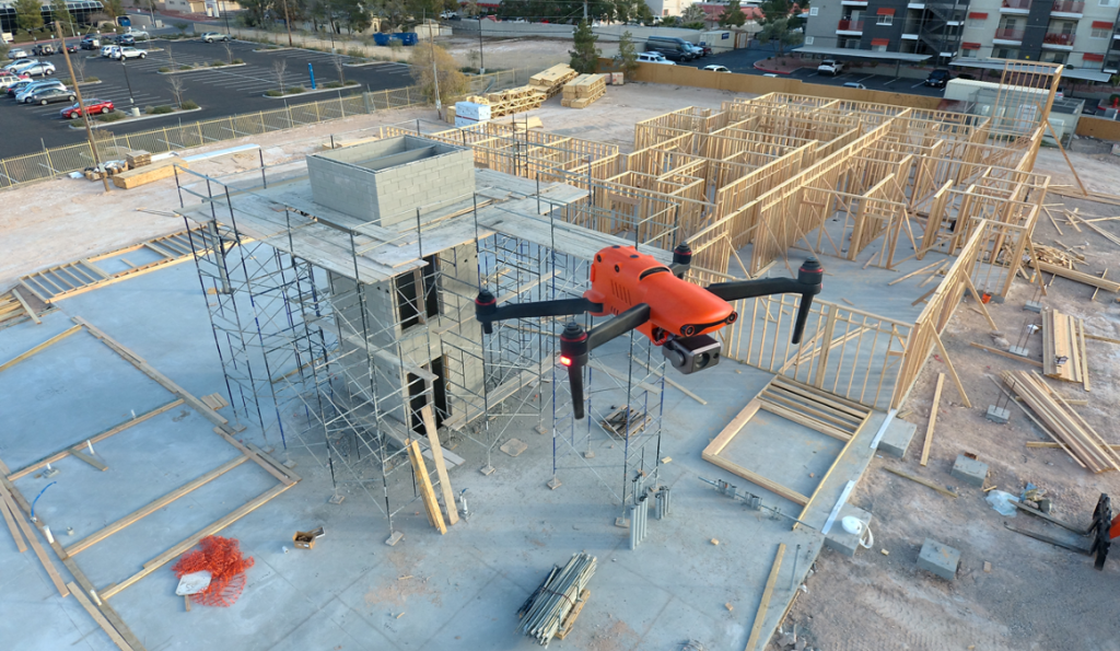
Unmanned Aircraft (UA/Drones) have rapidly become a significant component of the modern construction industry workflow whether it’s for progress reporting, site planning, BIM, inventory control, safety awareness, structure inspection, topo’s, or other purposes. Site supervisors, architects, and stakeholders all benefit from the rapid output of accurate 2D/Ortho, or 3D models that may be used for purposes ranging from simple visualizations, progress reporting, stockpile calculations, DSM, contours, to more complex overlaying blue-prints in the As-Designed/As-Built or BIM process.

Choosing the right aerial asset/UA may be challenging, particularly as the marketing of many UA is focused on RTK built in (rarely accurate) PPK solutions and a many component workflow versus others that are single-step workflows. Decisions on aircraft choices will be made based on budget, accuracy requirements, speed to result, and overall reporting requirements.

On any site flown for BIM, input to AutoDesk or similar tools, having accurate ground control points (GCP) is required. GCP’s may be obtained from the site surveyor, county plat, or other official sources, and this is often the best method assuming that the ground control points may be identified via UA flight-captured images. Site supervisors may also capture their own points using common survey tools. Devices such as the DTResearch 301 RTK tablet may be used to augment accuracy, combining GPC location points from the air and on the ground. Failing these methods, site supervisors can capture their own points based on the specific needs of the site. These points may be calculated via traditional rover/base RTK systems, or using PPK, RTK, or PPP solutions, again being budget and time dependent. If centimeter (vs decimeter) accuracy is required, RTK or PPK are necessary.

Putting accuracy aside, image quality is gaining importance as stakeholders have become accustomed to photo-grade ortho or models. Oftentimes, these models are used to share growth with inspectors as well, which means having presentation-grade images may be critical. Image quality is high priority when generating pre-development topos, or simply illustrating a tract of land from all directions. In other words, a high-quality imaging sensor (camera) is a necessity. Some aircraft allow user-choice cameras, while many UA manufacturers are creating cameras specific to their aircraft design.

Turning to aircraft, we chose three popular aircraft for the comparisons:

Flying the site several times in various conditions, the same RTK capture points are used in all three mapping projects. The DTResearch 301 RTK system is used to capture GCP on-location, with Hoodman GCP kit as the on-ground GCP. The Hoodman SkyRuler system was also captured as a scale-constraint checkpoint.

This commercial site is small in size (1.64 acres), and one we were able to begin capturing prior to forms being laid, all the way to vertical installation.

Accuracy varied greatly with each aircraft system, particularly in elevation calculations. Deviations are from projected points vs the GCP points obtained through a surveyor’s RTK system.
Overall (and to our surprise), the Autel EVO was most accurate with a deviation of:

  • x-5.112ft
  • y-47.827ft
  • z-16.541ft 

The Yuneec H520/E90 combo was not far behind with a deviation of:

  • X-10.323ft
  • y-44.225ft
  • z-92.788ft

Finally, the DJI Phantom 4 presented deviations of:

  • x-1.95ft
  • y-45.565ft
  • z-140.626ft 

All of these deviations are calculated and compensated for in Pix4DMapper, which is used to assemble all of these week-to-week projects.
As 3D modelling was part of the comparison/goal, obliques were flown in addition to nadir captures. While manual settings are often essential for high quality maps and models, in the following images cameras were all set to automatic exposure, shutter, ISO.

It is important to remember that these are NOT corrected via network nor base station. This is autonomous flight, localized in Pix4D.

MODELS

AUTEL EVO (Original version)
YUNEEC H520/E90
PHANTOM 4 PRO

All aircraft models work well with Pix4DMapper, although at the time of this writing, Pix4D has not created lens profiles for the Autel EVO (they have indicated this feature should be available “soon”). We custom-sized the lens profile ourselves, based on information provided by Autel’s product managers. *as of 2.1.22, Pix4D has generated lens profiles for both Autel EVO and EVO II aircraft.

Orthos

AUTEL EVO
YUNEEC H520/E90
PHANTOM 4 PRO

Although image quality is subjective, our client and our team all agree the Autel EVO provides the best image quality and color of all aircraft, with all aircraft set to automatic exposure, shutters peed, and ISO of 100. This is a surprise, given the Autel is a ½.3 imager, vs the 1” rolling shutter of Yuneec and global shutter of the DJI aircraft. Based on internet forums, Autel is very well known for their camera parameters being impressive.

All flights are single-battery flights. This is important, as changing batteries offers different functions for the various aircraft. Using Yuneec and DJI products and their respective software applications, we are able to fly larger sites with proper battery management with the aircraft returning to launch point when a battery is depleted and resume a mission where it left off once a fresh/charged battery is inserted. The Autel mission planner currently does not support multi-battery missions (although we’re told it will soon do so).

There are a few aspects to this workflow that are appreciated and some that are not. For example, when flying Autel and Yuneec products, we’re able to act as responsible pilots operating under our area wide Class B authorization provided by the FAA. To fly the DJI Phantom, the aircraft requires a DJI-provided unlock that permits flights. It’s a small annoyance, yet if one shows up on a jobsite not anticipating an unlock, it can be tedious. In some instances, we are just on the edge and outside controlled airspace, yet DJI’s extremely conservative system still requires an unlock. Most times, the unlock is very fast; other times, it doesn’t happen at all.

All three aircraft are reasonably fast to deploy, and this is important when a LAANC request for a zero-altitude grid is a short window. Autel clearly wins the prize for rapid deployment, with the EVO taking approximately 30 seconds to launch from case-open to in-the-air. Mission planning may be managed prior to flight and uploaded once the UA has left the ground. We are experiencing much the same with the latest release of the EVO II 1” camera as well. We also appreciated the lack of drift and angle in relatively high winds (26mph+).

DJI is next fastest at approximately three minutes, (assuming propellers remain attached in the case), while the mission planning aspect is a bit slower than the Autel system. DJI uploads the mission to the aircraft prior to launch. Of course, this is assuming we’ve already achieved an approval from DJI to fly in the restricted airspace, on top of the FAA blanket approval. If we don’t, we may find (and have found) ourselves unable to fly once on-site, due to glitches or slow response from DJI.

Yuneec is the slowest to deploy, given six props that must be detached for transport. Powering the ST16 Controller, attaching props, and waiting for GPS lock often requires up to five minutes. The mission planning tool (DataPilot) is significantly more robust than DJI’s GSPro, third party Litchi or other planning apps, and is far more robust than Autel Explorer’s mission planner. DataPilot also essentially ensures the mission will fly correctly, as it auto-sets the camera angle for different types of flight, reducing the margin for pilot error. The Yuneec H520 is superior in high winds, holding accurate position in reasonably high winds nearing 30mph.

Advertise with Us ›

All three aircraft turn out very usable models. All aircraft capture very usable, high-quality images. All of the aircraft are, within reason, accurate to ground points prior to being tied to GCP.

We were surprised to find we prefer the Autel EVO and are now completing this project after having acquired an Autel EVO II Pro with a 1” camera and 6K video.

Why?

Foremost, the Autel EVO family offered the most accurate positioning compared to the other aircraft in the many, many missions flown over this site. With dozens of comparison datasets, the Autel also offered the fastest deployment, and ability to fly well in high winds when necessary. The cost of the Autel EVO and EVO II Pro make this an exceptionally accessible tool and entirely reliable. That the Autel EVO requires no authorization from an overseas company, particularly in areas where we already have authorizations from the FAA, is significant to us, and the image quality is superior to either of the other aircraft.

We also greatly appreciate the small size of the aircraft, as it takes little space in our work truck, and our clients appreciate that we’re not invasive when working residential areas for them. The aircraft isn’t nearly as noisy as other aircraft, resulting in fewer people paying attention to the UA on the jobsite. The bright orange color, coupled with our FoxFury D3060 light kit (used even in daylight) assists in being able to see the aircraft quite easily, even when up against a white sky or dark building background.

We also of course, appreciate the speed in deployment. With safety checks, LAANC authorizations, planning a mission, and powering on remote and aircraft, the Autel EVO is deployable in under two minutes. When flying in G airspace, from case to airborne can be accomplished in under 30 seconds.

Battery life on the EVO 1 is substantial at 25 minutes, while our newly acquired EVO II Pro offers 40 minutes of flight time with incredible images to feed into Pix4D or other post-flight analytics software.

Of greatest importance, the EVO provides the most accurate XYZ location in-flight compared to the other aircraft. For those not using GPS systems such as the DTResearch 301 that we’re using on this project, accuracy is critical, and being able to ensure clean capture with accurate metadata is the key to successful mapping for input to Autocad applications.

WHERE TO LEARN MORE:

www.autel.com (UA, mission planning)

www.dtresearch.com (RTK Tablet with hyper-accurate antenna system)

www.dji.com (UA, mission planning)

www.foxfury.com (Lighting system for visualization)

www.hoodman.com (GCP, LaunchPad, SkyRuler)

www.Pix4D.com (Post-flight mapping/modelling software)

www.sundancemediagroup.com (training for mapping, Pix4D, public safety forensic capture)

www.yuneec.com/commercial (UA, mission planning)

With thanks to AutelHoodmanDTResearch, and Pix4D.

Promotional

Land Surveyors Association of Washington 2022 Annual Conference
March 2-4, 2022 Hilton Vancouver

Kuker-Ranken is excited to be a part of the LSAW which will be in beautiful Vancouver Washington at the Hilton-Vancouver.  This is exciting because our Portland location is located just 22 minutes away in downtown Portland on the corner at 308 SE Taylor Street.  If you have time stop in and look around.  For a limited time we’re offering all LSAW attendees and anyone with access to this page special promotional pricing on select items.

Autel EVO II RTK & Emlid Reach RS2 GNSS Receiver Bundle and your choice of PIX4D or Leica Infinity software.

The EVO II RTK Enterprise series integrates an entirely new RTK module, which provides real-time centimeter-level positioning data and supports Post-Processing Kinematic (PPK). The aircraft can record the original satellite observation data, camera exposure parameters and various other data. 

Reach RS2 gets a fixed solution in just seconds and maintains robust performance even in challenging conditions. Centimeter accuracy can be achieved on distances up to 60 km in RTK, and 100 km in PPK mode.  

PIX4D and Leica Infinity Software provide you with the standards in industry software for drone data processing.

Prices start at: $7,576 More information.

Leica RTC360 3D Laser Scanner 

The Leica RTC360 3D reality capture solution empowers users to document and capture their environments in 3D, improving efficiency and productivity in the field and in the office.  Capture scans, including enriching High-Dynamic Range (HDR) imagery, in less than two minutes.  Automatically record your moves from station to station to pre-register your scans in the field without manual intervention.


What is 3D Reality Capture?
3D reality capture is a process of scanning and capturing any site, for example plants, buildings or crime scenes, in a 3D digital model, combining measurements and imagery. The resulting model can be used for design and comparison purposes, to ensure site safety in inhospitable environments or as evidence in a criminal case, capturing every detail with to-the-millimetre accuracy.

Prices starting at: $78,300  More information.

Leica GNSS RTK Rover Smart Antennas

The Leica GS18 is a self-learning GNSS smart antenna.  It’s an excellent companion to a surveyor that primarily works with a network RTK such as HxGN SmartNet. Like most of the Leica Geosystems GNSS smart antennas, the GS18 works as a rover and a base.  Three models to choose from:

GS18 – The GS18 smart antenna that grows with your business: upgrade it to tilt-compensated rover at any time.  Leica GS18 T – Fast and easy-to-use GNSS RTK rover that has been exceeding expectations since 2017. The original truly tilt compensating GNSS solution that is immune to magnetic disturbances and is calibration-free.  

Leica GS18 I – Versatile, survey-grade GNSS RTK rover with Visual Positioning. Capture the site in images and measure points from them, either in the field or later in the office.

Prices starting at: $15,200  More information.

Emlid Survey Pole

A telescopic aluminum survey pole is designed for comfortable surveying. The three-section construction delivers reliable stability with the help of solid flip locks.

  • Lightweight at 1.75lbs
  • 5/8″ Thread
  • Includes carring bag
  • Retail Price: $199

Promotional Price: $179   More information.

Aervoe Survey Marking Paint in a variety of colors.

Aervoe Survey Marking Paint

A superior upside-down marking paint designed for survey marking. It provides the best quality paint in terms of color visibility, retention, and durability.  Aervoe Survey Marking Paint is the best marking paint of its kind. It is packaged in a can that is operated only in an upside-down position. 

It provides exceptional quality in terms of initial color brightness, color retention, adhesion, durability, and color consistency. It is formulated with superior quality raw materials to meet the requirements of the most demanding professional.  Your marks will be clean and consistent and will last up to 6 months.

Retail Price: 72.96 / case

Promotional Price: $54.72 / case  More information.

Hubs, Stakes, Lath and Lot Boards for Surveyors and Contractors

Cut from Douglas fir, our and lath is the strongest and straightest you will find. The finished products always have a nice finish that won’t tear up your markers. Our Douglas Fir/Larch hubs can take a beating! The long, 4 sided point pounds into the ground easier, resulting in less breakage.


For pricing and delivery to your location call 800-454-1310

Kuker-Ranken
21601 – 66th Ave. West Unit A
Mountlake Terrace, WA 98043
425-771-7776

Kuker-Ranken
308 SE Taylor Street
Portland, OR 97214
503-641-3388

Lunch and Learn

Lunch and Learn.

Kuker-Ranken (KR) Lunch & Learn sessions are short webinars designed to help the AEC, GIS, and Public Safety communities and hardware users get up to speed with what’s happening with Technology whether it’s unmanned, software, hardware, techniques, tips, best practices, or what’s new in the industry. 

At no cost to attendees, we’re grateful to our sponsors, partners, vendors, and customers for being a part of these 15-25 minute webinars. Ample time at the end of the session is available for any questions that you may have.

Precision takes flight logo.

Sign up to stay informed of all the upcoming Lunch and Learns.

Upcoming Lunch and learns.

 Past Events

November 29, 2023

Cold Weather UAS (Drone) Operations:  Batteries, Safety, Best Practices with Douglas Spotted Eagle

November 15, 2023

Remote ID for Drones: A discussion with Douglas Spotted Eagle

November 8, 2023

Survey Control for Non-Surveyors with Bryan Worthen

November 1, 2023

Introducing the Inspired flight IF1200A and 800A  with Brady Reisch

October 18, 2023

Leica Captivate Firmware updates with Jeremy Kippen

October 11, 2023

A discussion with Utah  LTAP on workflows in the field with Benjamin Goddard

October 4, 2023

Introducing Wingtra Fixed Wing with Brady Reisch.

September 27, 2023

Exporting data from Leica Infinity to MS cad with Jeremy Kippen

September 20, 2023

Captivate Version 8.0 New Features with Rob Mitchell

September 13, 2023

Leica Prisms – Looking back at you, exactly at you with Kyler Gould

August 30, 2023

Leica Distos – Pythagorean’s Laser Measuring Tapes with Kyler Gould

August 23, 2023

Leica Infinity Workflow with Jeremy Kippen

August 9, 2023

A comparison of LiDAR Trueview 435 vs 515 vs 660 with Brady Reisch with Brady Reisch.

August 2, 2023

A KR Panel Discussion of UAS on the jobsite with Brady Reisch, Ben Goddard and Douglas Spotted Eagle.

July 26, 2023

A Discussion of Photogrammetry and LiDAR with Brady Reisch

July 12, 2023

Introducing the Pix4D ViDOC with Brady Reisch

June 28, 2023

Leica Rugby Rotating Lasers – 610 to CLA-Active with Kyler Gould

June 21, 2023

Overview of the Leica RTC360 (models & options)with Jeremy Kippen

June 14, 2023

MicroSurvey Field Genius with Rob Mitchell

June 7, 2023 

Introducing a NEW LiDAR drone.  The Microdrone EasyOne with Brady Reish

May 24, 2023

An overview of available models of Leica TS16 Total Stations with Josh Crawford

May 17, 2023

Leica Total Station Review with Jeremy Kippen

May 12, 2023

LiDAR 101 with Brady Reisch LiDAR SME

May 5, 2023

Battery Management with Ben Goddard

April 26, 2023

Meet the team behind INSPIRED FLIGHT – a Blue List UAS made in the USA.

April 19, 2023

An overview of the Leica GS18 (models and options) with Jeremy Kippen

April 12, 2023

Mobile Mapping with ANYbotics ANYmal & ARC with Brady Reisch

April 5, 2023

Leica Cyclone Pegasus Classification Tools overview with Kyle Palmer of Leica Geosystems

March 29, 2023

An overview of the Leica CS20 (models and options) with Jeremy Kippen

March 22, 2023

Hemisphere GNSS Equipment Overview with Bryan Worthen

March 15, 2023

Introduction to MSCAD with James Johnston of MicroSurvey, and Mack Kowalski of KukerRanken.

March 8, 2023

Choosing a LiDAR Sensor – with Douglas Spotted Eagle

March 1, 2023

Understanding Leica Exchange – with Rob Mitchell

Feb 1, 2023

HxGN SmartNet Global – with Rob Mitchell

Jan 25, 2023

Introducing the Leica BLK360 G2 Scanner – with Mack Kowalski

Jan 18, 2023

Introduction to the NEW Autel V3 Series – with Douglas Spotted Eagle

Jan 11, 2023

RTK and PPK workflows – with Douglas Spotted Eagle and Brady Reisch

Jan 4, 2023

Cleaning tools in Leica 3DR – with Mack Kowalski

Dec 21, 2022

Introduction to UAS in Mapping – with Brady Reisch

Dec 14, 2022

Introduction to the ANYbotics ANYmal – with Brady Reisch

Dec 7, 2022

Classifications in 3DR – with Mack Kowalski

Nov 30, 2022

Introduction to MAPTEK – with Douglas Spotted Eagle

Nov 15, 2022

Leica AP20 Autopole – with Rob Mitchell

Nov 9, 2022

Augmented reality through vGIS – with Bryan Worthen

Nov 2, 2022

RTK and PPK workflows – with Roy Davis

Oct 26, 2022

GPR and bathy surveying – With Stewart Snider

Oct 19, 2022

Development of BIM & VDC technology in the industry – With Rob Mitchell

Oct 5, 2022

Geodesy 101 – with Bryan Worthen

Sept 28, 2022

GEOMAX ZENITH 60 AND FIELD GENIUS with Jeremy Kippen

Sept 21, 2022

Review of night flight at CommUAV – with Douglas Spotted Eagle

Aug 31, 2022

Introduction to the DJI M30 – with Darrell Madison

August 10, 2022

Workflow:  AutoDesk Revit to Leica Infinity to Captivate – with Mack Kowalski

July 27, 2022

An introduction to the Leica BLK2FLY – Douglas Spotted Eagle and Bryan Baker of Leica Geosystems

July 20, 2022

New Features in Cyclone Register 360 – with Mack Kowalski

July 13, 2022

DJI vs Microdrone LiDAR output comparisons – with Douglas Spotted Eagle and Brady Reisch

July 6, 2022

Achieving instant Airspace Authorizations – with Douglas Spotted Eagle and Brady Reisch

June 29, 2022

Using Leica Cyclone Register 360 to combine drone photogrammetry and Laser Scanning Data – Bryan Worthen

February 9, 2022

Autel EVO II Enterprise & Accessories  – with Douglas Spotted Eagle

January 13, 2022

Accuracy vs Precision – With Bob Lycke and Bryan Worthen

December 8, 2021

An Introduction to DT Research Tablets – with Stewart Snider

December 1, 2021

An Introduction to EMLID REACH RS2 Multi-band RTK Receiver for Drones – with Brady Reisch

November 10, 2021

Tablets Versus Handheld Data Controllers – with Kirez Reynolds

November 3, 2021

Which Mapping Software Shoud You Use? – with Brady Reisch

October 27, 2021

Live from UDOT Annual Conference 2021 – with Kuker-Ranken

August 4, 2021

Best Practices for Drone Workflows on the Worksite – with Brady Reisch

July 19, 2021

Autel EVO II RTK Aircraft Overview and Workflow – Rebroadcast with Douglas Spotted Eagle

July 14, 2021

Introduction to iCON Construction Software – Adam Huff

June 24, 2021

Introducing the Autel EVO II RTK Aircraft and Workflow –  Douglas Spotted Eagle

June 23, 2021

Leica Cyclone Part #1 – Peyton Hatch

June 16, 2021

Introduction to Microdrones – Aaron Beach

June 9, 2021

MicroDrones & Autel – Live from World of Concrete 2021 – Douglas Spotted Eagle, Aaron Beach, Brady Reisch

June 2, 2021

Large Area Mapping with Drones – Workflow Overview – Douglas Spotted Eagle

Boise, Idaho Location

Boise, Idaho Location

Our Boise location is located in the Central Valley region of Idaho just NW of downtown Boise.

This location is operated by Arlene Crawford our Office Manager and Darrell Madison who has a wealth of knowledge in the drone and construction industry. 

Similar to our other locations you’ll always find a large stock of paint, wood, nails and tape and a lot more. 

We invite you to stop in to see us.

KR Customer Appreciation BBQ’s – Save the Date!

They’re Baaack! Our Customer Appreciation BBQ’s are back! Save the dates and join us for a FREE meal, drinks and time with your favorite KR employees.  

Kuker-Ranken Boise, Idaho Office.  July 18th, 2024

Arlene Crawford
Sales Manager

Darrell Madison
Geomatics / UAS Specialist

Store Location
4686 W. Chinden Blvd.
Garden City, ID 83714

Boise Hours
Monday – Friday: 7:00 AM to 4:00 PM (MST)
Saturday: Closed
Sunday: Closed

Come see us, or call us
Phone: 208-369-4388

Technical Support
Phone: 425-953-2825

GENERAL INFORMATION CONTACT FORM.  Fill out the form completely, you’ll be contacted by someone from our Boise location shortly.