LiDAR
“LiDAR” is an acronym for “Light Detection And Ranging.”
When LiDAR is activated, a laser beam with measuring capability is fired from the LiDAR mirror/head. When the beam strikes an object, it returns the difference in time, indicating distance, to the LiDAR processing system.
LiDAR may be a spinning mirror configuration, or solid state operation, or a blend of each.
The system is significantly greater than merely spinning lasers. An IMU (inertial measurement unit) calculates the precise range and records it as an XYZ “point.” These various points, collected in the hundred of thousands, or millions, together make up a “point cloud,” offering up a visual display of the area being measured, scanned, and/or surveyed.
TERRESTRIAL/GROUND LiDAR
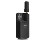
Terrestrial LiDAR is ground-based LiDAR, either static or mobile. Whether mounted on a heavy tripod to avoid ground vibration, or hand-held such as the Pix4D viDOC or Leica BLK series hand-held scanners, these systems are designed for indoor and outdoor applications.
LiDAR scanners are differentiated by resolution and range. The IMU plays a critical role in the precision of the system, in addition to the range of the laser, number of returns, and speed of system.
For example, the RTC360 is the “granddaddy” of laser systems, scanning in all directions (up, down, 360) while mounted on a tripod (RTC scan example), all the way down to the iPhone-based Pix4D viDoc. (viDoc scan example 1 viDOC scan example 2)
All of our scanning systems are able to capture data for point cloud visualization, and pointclouds may be colorized to provide photo-realistic display for most applications.

AERIAL LiDAR
With the advent of UAS/drones capable of heavier lift for larger payloads such as LiDAR scanners, often combined with RGB cameras for dual-capture/photogrammetry, or low-resolution RGB for pointcloud colorization, UAS are rapidly shifting the landscape for scanning for BIM, As-Built, asset inspection, volumetrics, survey, and much more.
Aerial systems save significant amounts of time in the field, and some of our clients have told us they enjoy 8x time-savings through using LiDAR UAS.
Why?
LiDAR aircraft can cover an acre an hour, generating millions if not billions of points for a dense pointcloud. The average manual survey can capture a couple hundred points an hour. Additionally, UAS can cover large swatchs of area, peering through heavy vegetation, providing extremely accurate surface, terrain, and elevation models in minutes. Most of our systems can process data in the field, providing opportunity to capture more data if needed, or generating greater densities in the event an initial flight missed areas of record.


