Viva Las Vegas (LiDAR Excitement)

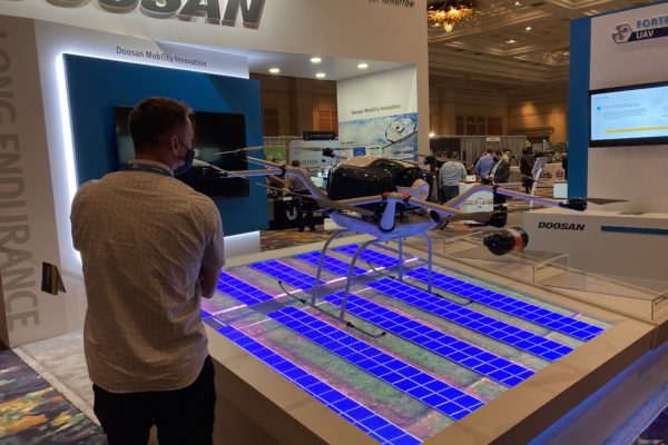
Commercial UAV Expo effervesces in LiDAR and Face to Face gathering

DR. A. STEWART WALKER 09.22.2021

Diversified Communications is the very model of a modern conference company, but even its most experienced managers must have harbored slivers of doubt as they prepared the Commercial UAV Expo Americas, in the Mirage, Las Vegas, on 7-9 September. If we make it, will they come? Will they be so desirous of renewed face-to-face contact that the conference is a sell-out, or will they be unsure, unvaccinated or unmasked, therefore unwilling to risk it?

It turned out to be the former. The event was a huge success and participants reveled in being back together. The raw numbers, provided by DivCom’s genial and extremely knowledgeable event strategist, Carl Berndtson, were: 2767 registrants from 61 nations and all 50 states, 130 exhibitors (the hall included a Korean pavilion for the first time), 12 product launches, 150 speakers and double the projected attendance in the conference sessions. Registration reached 88% of the 2019 figure, way higher than many other conferences that have happened in recent months.

The outdoor demos were a sell-out, with 300 attendees. We were bused to the site near Henderson, Nevada. The shadeless bleachers became brutal as the morning wore on and the temperature rose towards 35°C, but compere Douglas Spotted Eagle of Sundance Media Group and KukerRanken, a regular at these events, repeatedly enjoined attendees to partake of the water provided, so casualties were minimal. We saw UAVs flown in 20-minute slots by Skyfront, CommAris (a brand of Terrafugia, the flying car people), Doosan Mobility Innovation, Skydio, AEE Technology, Autel Robotics, and BRINC/Adorama Business Solutions. This immediately underlined a theme of the conference, the real and increasing role of UAVs in emergency management, first response, and search and rescue. Another very apparent feature was the number of large aircraft, always, however, below the 55 lb limit. Skyfront’s multi-rotor, long-endurance UAV, with a gas engine generating electricity to drive the propellers, can carry a YellowScan lidar, though the large number of available payloads have somewhat of a defense focus. Douglas Spotted Eagle conducted an unscripted show of hands of the audience to see who was using lidar: there were nine responses from the bleachers, five using DJI, one Microdrones and three YellowScan.

Next on was CommAris, the big Seeker long-endurance VTOL requiring two crew with full jumpsuits and helmets to get it airborne. Despite its size (15’ wingspan), the Seeker can be quickly assembled in the field and can carry a 10-lb payload. I spoke to the CommAris folk in the exhibition: so far they don’t have a lidar customer, but they expect several and will keep us informed. As it flew, we saw a hawk (the bird, not the name of another UAV) fly near to take a look, but it elected not to attack. Doosan’s UAV was carrying a USPS package. It uses a hydrogen cell to increase endurance and brought home to us, if we weren’t already believers, that the carrying of packages by UAVs is happening in many countries and is a reality, no longer confined to carrying anti-venom in the remote Amazon, but likely soon to be part of daily life for the non-fluvial Amazon, Walmart and others. Indeed, Walmart’s “director last mile” gave a keynote on Thursday.

IMG 0446 600x400

Doosan Mobility Innovation, indoors at Commercial UAV Expo 2021.

Act five was the public debut of the Mach 6 UAV from AEE, focused on public safety, with dual batteries to increase endurance. Though the payloads shown were not geospatial (thermal imagery of the audience; megaphone; delivery of automated external defibrillator through a partnership with Schiller Medical), the Mach 6 could easily carry lidar. It uses radar for collision avoidance and AEE has BVLOS very much in mind. AEE was followed by another new product, the Skydio X2. The firm has a defense focus and has won an AUVSI Excellence in Innovation award. The demo involved imagery and the creation of a mesh with photogrammetry – no mention of lidar. Like all the presenters, the Skydio team explained aspects of their software using both PowerPoint and live demos on the big screen, though bright sunlight and intense heat sapped audience concentration.

The Autel Dragonfish VTOL is not new, but has evolved considerably from earlier models. The aircraft has a two-hour endurance and offers a terrain-following feature. After the mission, it landed perfectly on the mat provided for it. The audience consisted on UAV veterans, yet this pinpoint ability – which all demos featured – never failed to raise some applause. The last performer was BRINC Drones, a Las Vegas company, assisted by Adorama. Its Lemur S, aimed at the public safety market, uses lidar to help navigation, but not for geospatial purposes. Nevertheless, this remarkable aircraft is worth a few words: if it crashes and tips over, it can get up, right itself and resume the mission; and it was demonstrated with an attachment that can break glass! The latter was used to enter a small hut on the demo site, and we were also shown the UAV flying thermal imagery inside a school bus. Truly remarkable!

IMG 0445 600x400

Commercial UAV Expo 2021 attendees

Thus ended a wonderful morning, impressing upon us the progress being made by UAVs to the extent that they are part of daily life. The efforts of the firms’ personnel, some of whom had been out to the site on one or two previous occasions to rehearse, deserved applause – they had suffered the torrid conditions in order to make our time as productive as possible.

Returning from the desert, we had to prepare quickly for the afternoon fare, the product preview presentations. As always, these were a bit of an endurance test, with 17 15-minute presentations in each of two rooms, necessitating agile jumping between the two in pursuit of the best mix. There were frustrations – ASPRS did not speak at the time advertised on the program, and RIEGL and LiDAR USA were on at the same time – yet the speakers managed to overcome the temptations to firehose us with small detail of their products and the afternoon passed quickly and informatively. There was too much here to report in a few words, but it’s worth following up the geospatial lidar players by looking at their websites for the latest developments, such as DJI, GeoCue, Leica Geosystems, LiDAR USA, RIEGL, SimActive and YellowScan, and imaging players such as AgEagle and Phase One.

After the demanding first day, the event resumed on the Wednesday with opening remarks from DivCom director Lee Corkhill. Top of the bill keynote was Stephen Dickson, FAA Administrator (ex USAF and Delta). He gave a fine presentation, but, as usually happens in these events, once its representative had departed, FAA was targeted with some less than complimentary remarks by later speakers, all of whom are anxious to fly BVLOS, or in the dark, or over populated areas, or all of the above, sooner rather than later. As Stephen said, lots of progress has been made on night flying, but for other desires waivers are the current way to go, so we’re at an inflection point as this process cannot be sustained at scale. Whatever other speakers may have felt, there is no doubt that FAA is busy and one cannot argue with Stephen’s closing remarks, “Safety is a journey, not a destination”, and his emphases on humility and safety.

There was too much in the show to spend time on every booth. Among highlights were, prominent on the DJI booth, an M600 with the Zenmuse L1 lidar sensor. Phase One had a new camera, the P3, complete with gimbal. Emesent had the Hovermap lidar sensor, complete with SLAM software, i.e. it also works in GNSS-denied environments, which can be mounted on UAVs, or land vehicles, or in a backpack of hand-carried – indeed, Emesent perhaps stole the show by showing it on the back of Spot, the robotic dog from Boston Dynamics (remember reading about it in LIDAR Magazine?[1]). Leica Geosystems introduced BLK2FLY, its gorgeous new laser scanner snuggling inside a quadcopter, also called an “autonomous flying laser scanner”. The software is richly furnished with SLAM as well as GNSS/IMU components. Some of the exhibitors gave additional presentations in the theater set up in the exhibition hall, so there was no excuse not to find out about products of interest.

LIDAR Magazine was invited to participate in the “Meet the Press” event. Of the 25 firms who entered, 16 sent representatives to the one-hour live event, at which they spoke for two minutes each, followed by one minute for questions. The speakers entered into the spirit of this “fun” session and fielded the questions both competently and with a sense of humor. The journalists went into purdah and chose Emesent, BRINC Drones and vHive as winners[2].

PXL 20210908 224737409.MP  600x400

Teledyne FLIR spokesperson shares a new sensor with the press.

Amongst all this, I attended as many sessions as possible. Jeremiah Karpowicz of DivCom conducted a good on-stage discussion with Brandon Torres Declet, the new CEO of AgEagle. DivCom favors a formula where part or all of almost every session is a panel discussion, with several experts on stage. Some of these were a tad thin or repetitive, but invariably attorneys, police officers and firefighters did well. These people may not be ideal to discern trends for us after a moment’s thought, but they are performing or managing UAV flights in the thousands every year, so listen up! We’ve moved from shiny toys to commercialization, rapidly and successfully. A session on construction revealed what could be done, for example measuring cranes, flare structures, Las Vegas’s Allegiant Stadium. UAV-delivery firms Zipline and DroneUp both made deep impressions.

Towards the end of the conference, our regular contributor Lewis Graham chaired a session on surveying and mapping. I felt on more familiar ground here as speakers from Ohio UAS Center and The Ohio State University talked about the multiplicity of projects they had completed, while sometimes humorously referring to some of the day-to-day problems they encountered. Also in this session was one of the firms from the Korean pavilion in the exhibition, describing UAV-based geomatics land data acquisition in Ethiopia, using a UAV built in Korea.

ASPRS ran four two-hour workshops, two on Wednesday and two on Thursday, one pair on UAV-photogrammetry and one on UAV-lidar. All were well attended, confirming the thirst for knowledge that was so obvious from the buzz and attendance at this event

The DivCom sales team was energetically working the halls and must have a good chance of following the sell-out exhibition with another one at the Geo Week conferences in Denver in February 2022, where ILMF, AEC Next, SPAR 3D, ASPRS and USIBD will be combined. Meanwhile, LIDAR Magazine was taking every opportunity to solicit firms for articles, as a result of which we are working with DJI, Emesent, LightWare, Phoenix LiDAR Systems, SimActive and several others.

DivCom has decided to change the venue of Commercial UAV Expo Americas and the next iteration of the event will be at Caesars Forum on 6-8 September 2022. LIDAR Magazine would have preferred a slot later in the year, so we would be less well done at the outdoor demos, but won’t hesitate to be there, to learn, enjoy, contribute and be thankful. While the scope of UAVs extends far beyond the geospatial, and the lidar vertical is but a small part of a market dominated by public safety and parcel deliveries, I wouldn’t willingly miss this event. The UAV world is fast moving and more than one company said it was in robotics rather than drones. DivCom’s formula of a technology-based rather than market-based event works and the wide range of backgrounds of attendees is a big plus. I felt almost overwhelmed by information, yet stimulated, inspired and anxious to reflect in order to get it all into perspective. Probably that’s what a successful conference event should inspire!

As I finished this report, HxGN LIVE GeoSummit and Intergeo, remote and hybrid respectively, were swinging into action. Once again, we’re in the thick of development and struggling to assimilate all the news and innovations. It’s a great time to be in lidar!

Does the Drone Industry Really Need 8K

Does the Drone Industry Really Need 8K?

Pro Read: As a leak indicates that Autel Robotics may be the first to offer a 6/8K camera on a drone, UAS expert and industry leader Douglas Spotted Eagle dives in to what the advantages of 8k may be – and if the drone industry is ready to take advantage of them.

Guest post by Douglas Spotted Eagle, Chief Strategy Officer – KukerRanken

In 2004, Sony released the world’s first low-cost HD camera, known as the HVR-Z1U. The camera featured a standard 1/3” imager, squeezing 1440×1080 pixels (anamorphic/non-square) pixels on to the sensor. This was also the world’s first pro-sumer camera using the MPEG2 compression scheme, with a color sample of 4:2:0, and using a GOP method of frame progression, this new technology set the stage for much higher resolutions and eventually, greater frame rates.

It’s “father,” was the CineAlta HDWF900, which offered three 2/3” CCDs, which was the industry standard for filmmaking for several years, capturing big hits such as the “Star Wars Prequel Trilogy”, “Once Upon a Time in Mexico”, “Real Steel”, “Tomorrowland”, “Avatar”, “Spykids” (1 & 2), and so many others.  The newer HDV format spawned from similar technology found in the HDWF900, and set the stage for extremely high end camera tech to trickle down into the pro-sumer space.

Overtime, camera engineers identified methods of co-siting more pixels on small imagers, binning pixels, or using other techniques to increase the capture resolution on small surfaces. Compression engineers have developed new compression schemes which brought forward AVC (h.263), MP4(h.264), and now HEVC/High Efficiency Video Codec(h.265), and still others soon to be revealed.

Which brings us to the present.

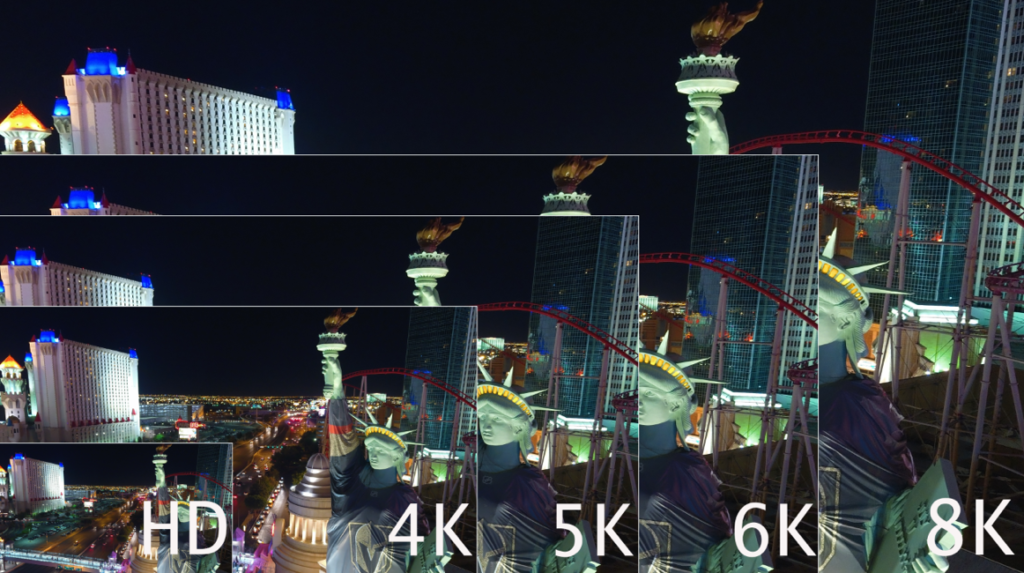
We have to roughly quadruplemegapixels to doubleresolution, so the jump from SD to HD makes sense, while the jump from HD to UHD/4K makes even more sense. Following that theme, jumping to 6K makes sense, while jumping to 8K is perfect theory, and nears the maximum of the human eye’s ability to resolve information.

At NAB 2018, Sony and Blackmagic Design both revealed 8K cameras and in that time frame others have followed suit.

During CommUAV and InterDrone, several folks asked for my opinion on 6 and 8K resolutions. Nearly all were shocked as I expressed enthusiasm for the format.

–          “It’s impossible to edit.”

–          “The files are huge.”

–          “No computer can manage it.”

–          “There is no where to show 8K footage.”

–          “Human eyes can’t resolve that resolution unless sitting very far away from the screen.”

–          “Data cards aren’t fast enough.”

And….so on.

These are all the same comments heard as we predicted the tempo of the camera industry transitioning from SD to HD, and from HD to 4K.  In other words, we’ve been here before.

Video cameras are acquisition devices. For the same reasons major motion pictures are acquired at the highest possible resolutions, and for the same reasons photographers get very excited as resolutions on-camera increase, so should UAS photographers. Greater resolution doesn’t always mean higher grade images. Nor does larger sensor sizes increase quality of images. On the whole, higher resolution systems usually does translate into higher quality images.

Sensor sizes are somewhat important to this discussion, yet not entirely critical. The camera industry has been packing more and more pixels into the same physical space for nearly two decades, without the feared increase in noise. Additionally, better noise-sampling/reduction algorithms, particularly from OEM’s like Sony and Ambarella, have allowed far greater reduction in noise compared to the past. Cameras such as the Sony A7RIV and earlier offer nearly noise-free ISO of 32,000!

Sensor sizes vary of course, but we’ll find most UAS utilize the 1/2.3, or the 1” sensor. (Light Blue and Turquoise sizes respectively, as seen below).

“Imagine an UAS equipped with an 8K camera inspecting a communications tower. Resolution is high, so small specs of rust, pitting, spalling, or other damage which might be missed with lower resolutions or the human eye become apparent with a greater resolution.”

WHY DOES HIGHER RESOLUTION TRANSLATE TO BETTER FINISHED PRODUCT?

Generally, we’re downsampling video or photos to smaller delivery vehicles, for but one reason. In broadcast, 4:2:2 uncompressed color schemes were the grail. Yet, most UAS cameras capture a 4:2:0 color/chroma sample.  However, a 4K capture, downsampled to 1080 at delivery, offers videographers the same “grail” color schema of 4:2:2!

As we move into 6 or 8K, similar results occur. 8K downconverted to HD offers a 4:4:4 color sample.

CROPPING

We gain the ability to crop for post editing/delivery to recompose images without fear of losing resolution. This means that although the aircraft may shoot a wide shot, the image may be recomposed to a tighter image in post, so long as the delivery is smaller than the source/acquisition capture. For example, shooting 4K for 1080 delivery means that up to 75% of the image may be cropped without resolution loss.

As the image above demonstrates, it’s quite possible to edit 8K HEVC streams on a newer laptop. Performance is not optimal without a great deal of RAM and a good video card, as HEVC requires a fair amount of horsepower to decode. The greater point, is that we can edit images with deep recomposition. Moreover, we have more pixels to work with, providing greater color correction, color timing, and depth/saturation.

For public safety, this is priceless. An 8K capture provides great ability to zoom/crop deeply into a scene and deliver much greater detail in HD or 4K delivery.

The same can be said for inspections, construction progress reports, etc. Users can capture at a high resolution and deliver in a lower resolution.

Another benefit of 6 and 8K resolutions is the increase in dynamic range. While small sensors only provide a small increase in dynamic range, a small increase is preferable to no increase.

To address other statements about 6K and 8K resolutions; They human eye has the ability to see around 40megapixels, age-dependent. 8K is approximately 33megapixels. However, the human eye doesn’t see equal resolutions across the surface. The center of our eye sees approximately 8megapixels, where the outer edges are not as deep. High resolution does provide greater smoothing across the spectrum, therefore our eyes see smoother moving pictures.

BEYOND THE HUMAN EYE

Going well-beyond the human eye, higher resolutions are applicable to “computer vision,” benefiting mapping, 3D modeling, and other similar applications. Generally speaking, more pixels equals greater smoothness and geometry. As technology moves deeper into Artificial Intelligence, higher resolutions with more efficient codecs become yet even more important. Imagine an UAS equipped with an 8K camera inspecting a communications tower. Resolution is high, so small specs of rust or other damage which might be missed with lower resolutions or the human eye become more visible with a greater resolution. Now imagine that greater resolution providing input to an AI-aided inspection report that might notify the operator or manager of any problem. Our technology is moving beyond the resolution of the human eye for good reason.

DATA STORAGE

Files from a 6 or 8K camera are relatively small, particularly when compared to uncompressed 8K content (9.62TB per hour). Compression formats, known as “Codecs” have been improving for years, steadily moving forward. For example, when compressions first debuted in physical form, we saw Hollywood movies delivered on DVD. Then we saw HD delivered on Blu-ray. Delivery over disc formats is dead, and now we’ve moved through MPG2, AVC, AVCHD, H.264, and now H.265/HEVC. In the near future we’ll see yet even more compression schemes benefitting our workflows whether delivered via streaming or thumbdrive.  VVC or “Versatile Video Codec”will be the next big thing in codecs for 8K, scheduled to launch early 2022.

Unconventional h.264 and H.265/HEVCare currently being used as delivery codecs for compressed 6 and 8K streams. 8K has been successfully broadcast (in testing environments) at rates as low as 35Mbps for VOD, while NHK has set the standard at 100Mbps for conventional delivery. Using these codecs, downconverting streams to view OTA/Over The Air to tablets, smartphones, or ground station controllers is already possible. It’s unlikely we’ll see 8K streaming from the UAS to the GSC.

U3 Datacards are certainly prepared for 6 and 8K resolutions/datastreams; compression is what makes this possible.  The KenDao 8K and Insta 8K 360 cameras both are recording to U3 cards, available in the market today.

It will be some time before the average consumer will be seeing 8K on screens in their homes. However, 8K delivered for advertising, matching large format footage being shot on Weapon, Monstro, Helium or other camera formats may be less time-consuming when using 8K, even from smaller camera formats carried on an UAS (these cameras may easily be carried on heavy-lift UAS).

Professional UAS pilots will benefit greatly from 5, 6, or 8K cameras, and should not be shy about testing the format. Yes, it’s yet another paradigm shift in an always-fluid era of aerial and visual technology.  There can be no doubt that these higher resolutions provide higher quality in any final product.  Be prepared; 2020 is the year of 5, 6, and 8K cameras on the flying tripods we’re using for our professional and personal endeavors, and I for one, am looking forward to it with great enthusiasm.

Selecting the Right Drone for Your Construction Business

Selecting the Right Drone for Your Construction Business

Douglas Spotted Eagle and Brady Reisch headed into the field to collect aerial construction data over fourteen weeks with three different drones.  Their goal was to determine which drone was best for the construction job site.

They used three popular aircraft for the comparisons and the results were pretty surprising.   

Drones Compared:

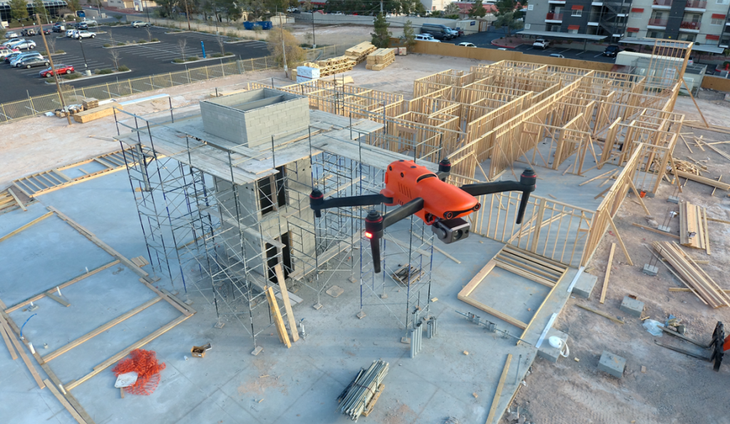
Unmanned Aircraft (UA/Drones) have rapidly become a significant component of the modern construction industry workflow whether it’s for progress reporting, site planning, BIM, inventory control, safety awareness, structure inspection, topo’s, or other purposes. Site supervisors, architects, and stakeholders all benefit from the rapid output of accurate 2D/Ortho, or 3D models that may be used for purposes ranging from simple visualizations, progress reporting, stockpile calculations, DSM, contours, to more complex overlaying blue-prints in the As-Designed/As-Built or BIM process.

Choosing the right aerial asset/UA may be challenging, particularly as the marketing of many UA is focused on RTK built in (rarely accurate) PPK solutions and a many component workflow versus others that are single-step workflows. Decisions on aircraft choices will be made based on budget, accuracy requirements, speed to result, and overall reporting requirements.

On any site flown for BIM, input to AutoDesk or similar tools, having accurate ground control points (GCP) is required. GCP’s may be obtained from the site surveyor, county plat, or other official sources, and this is often the best method assuming that the ground control points may be identified via UA flight-captured images. Site supervisors may also capture their own points using common survey tools. Devices such as the DTResearch 301 RTK tablet may be used to augment accuracy, combining GPC location points from the air and on the ground. Failing these methods, site supervisors can capture their own points based on the specific needs of the site. These points may be calculated via traditional rover/base RTK systems, or using PPK, RTK, or PPP solutions, again being budget and time dependent. If centimeter (vs decimeter) accuracy is required, RTK or PPK are necessary.

Putting accuracy aside, image quality is gaining importance as stakeholders have become accustomed to photo-grade ortho or models. Oftentimes, these models are used to share growth with inspectors as well, which means having presentation-grade images may be critical. Image quality is high priority when generating pre-development topos, or simply illustrating a tract of land from all directions. In other words, a high-quality imaging sensor (camera) is a necessity. Some aircraft allow user-choice cameras, while many UA manufacturers are creating cameras specific to their aircraft design.

Turning to aircraft, we chose three popular aircraft for the comparisons:

Flying the site several times in various conditions, the same RTK capture points are used in all three mapping projects. The DTResearch 301 RTK system is used to capture GCP on-location, with Hoodman GCP kit as the on-ground GCP. The Hoodman SkyRuler system was also captured as a scale-constraint checkpoint.

This commercial site is small in size (1.64 acres), and one we were able to begin capturing prior to forms being laid, all the way to vertical installation.

Accuracy varied greatly with each aircraft system, particularly in elevation calculations. Deviations are from projected points vs the GCP points obtained through a surveyor’s RTK system.
Overall (and to our surprise), the Autel EVO was most accurate with a deviation of:

  • x-5.112ft
  • y-47.827ft
  • z-16.541ft 

The Yuneec H520/E90 combo was not far behind with a deviation of:

  • X-10.323ft
  • y-44.225ft
  • z-92.788ft

Finally, the DJI Phantom 4 presented deviations of:

  • x-1.95ft
  • y-45.565ft
  • z-140.626ft 

All of these deviations are calculated and compensated for in Pix4DMapper, which is used to assemble all of these week-to-week projects.
As 3D modelling was part of the comparison/goal, obliques were flown in addition to nadir captures. While manual settings are often essential for high quality maps and models, in the following images cameras were all set to automatic exposure, shutter, ISO.

It is important to remember that these are NOT corrected via network nor base station. This is autonomous flight, localized in Pix4D.

MODELS

AUTEL EVO (Original version)
YUNEEC H520/E90
PHANTOM 4 PRO

All aircraft models work well with Pix4DMapper, although at the time of this writing, Pix4D has not created lens profiles for the Autel EVO (they have indicated this feature should be available “soon”). We custom-sized the lens profile ourselves, based on information provided by Autel’s product managers. *as of 2.1.22, Pix4D has generated lens profiles for both Autel EVO and EVO II aircraft.

Orthos

AUTEL EVO
YUNEEC H520/E90
PHANTOM 4 PRO

Although image quality is subjective, our client and our team all agree the Autel EVO provides the best image quality and color of all aircraft, with all aircraft set to automatic exposure, shutters peed, and ISO of 100. This is a surprise, given the Autel is a ½.3 imager, vs the 1” rolling shutter of Yuneec and global shutter of the DJI aircraft. Based on internet forums, Autel is very well known for their camera parameters being impressive.

All flights are single-battery flights. This is important, as changing batteries offers different functions for the various aircraft. Using Yuneec and DJI products and their respective software applications, we are able to fly larger sites with proper battery management with the aircraft returning to launch point when a battery is depleted and resume a mission where it left off once a fresh/charged battery is inserted. The Autel mission planner currently does not support multi-battery missions (although we’re told it will soon do so).

There are a few aspects to this workflow that are appreciated and some that are not. For example, when flying Autel and Yuneec products, we’re able to act as responsible pilots operating under our area wide Class B authorization provided by the FAA. To fly the DJI Phantom, the aircraft requires a DJI-provided unlock that permits flights. It’s a small annoyance, yet if one shows up on a jobsite not anticipating an unlock, it can be tedious. In some instances, we are just on the edge and outside controlled airspace, yet DJI’s extremely conservative system still requires an unlock. Most times, the unlock is very fast; other times, it doesn’t happen at all.

All three aircraft are reasonably fast to deploy, and this is important when a LAANC request for a zero-altitude grid is a short window. Autel clearly wins the prize for rapid deployment, with the EVO taking approximately 30 seconds to launch from case-open to in-the-air. Mission planning may be managed prior to flight and uploaded once the UA has left the ground. We are experiencing much the same with the latest release of the EVO II 1” camera as well. We also appreciated the lack of drift and angle in relatively high winds (26mph+).

DJI is next fastest at approximately three minutes, (assuming propellers remain attached in the case), while the mission planning aspect is a bit slower than the Autel system. DJI uploads the mission to the aircraft prior to launch. Of course, this is assuming we’ve already achieved an approval from DJI to fly in the restricted airspace, on top of the FAA blanket approval. If we don’t, we may find (and have found) ourselves unable to fly once on-site, due to glitches or slow response from DJI.

Yuneec is the slowest to deploy, given six props that must be detached for transport. Powering the ST16 Controller, attaching props, and waiting for GPS lock often requires up to five minutes. The mission planning tool (DataPilot) is significantly more robust than DJI’s GSPro, third party Litchi or other planning apps, and is far more robust than Autel Explorer’s mission planner. DataPilot also essentially ensures the mission will fly correctly, as it auto-sets the camera angle for different types of flight, reducing the margin for pilot error. The Yuneec H520 is superior in high winds, holding accurate position in reasonably high winds nearing 30mph.

Advertise with Us ›

All three aircraft turn out very usable models. All aircraft capture very usable, high-quality images. All of the aircraft are, within reason, accurate to ground points prior to being tied to GCP.

We were surprised to find we prefer the Autel EVO and are now completing this project after having acquired an Autel EVO II Pro with a 1” camera and 6K video.

Why?

Foremost, the Autel EVO family offered the most accurate positioning compared to the other aircraft in the many, many missions flown over this site. With dozens of comparison datasets, the Autel also offered the fastest deployment, and ability to fly well in high winds when necessary. The cost of the Autel EVO and EVO II Pro make this an exceptionally accessible tool and entirely reliable. That the Autel EVO requires no authorization from an overseas company, particularly in areas where we already have authorizations from the FAA, is significant to us, and the image quality is superior to either of the other aircraft.

We also greatly appreciate the small size of the aircraft, as it takes little space in our work truck, and our clients appreciate that we’re not invasive when working residential areas for them. The aircraft isn’t nearly as noisy as other aircraft, resulting in fewer people paying attention to the UA on the jobsite. The bright orange color, coupled with our FoxFury D3060 light kit (used even in daylight) assists in being able to see the aircraft quite easily, even when up against a white sky or dark building background.

We also of course, appreciate the speed in deployment. With safety checks, LAANC authorizations, planning a mission, and powering on remote and aircraft, the Autel EVO is deployable in under two minutes. When flying in G airspace, from case to airborne can be accomplished in under 30 seconds.

Battery life on the EVO 1 is substantial at 25 minutes, while our newly acquired EVO II Pro offers 40 minutes of flight time with incredible images to feed into Pix4D or other post-flight analytics software.

Of greatest importance, the EVO provides the most accurate XYZ location in-flight compared to the other aircraft. For those not using GPS systems such as the DTResearch 301 that we’re using on this project, accuracy is critical, and being able to ensure clean capture with accurate metadata is the key to successful mapping for input to Autocad applications.

WHERE TO LEARN MORE:

www.autel.com (UA, mission planning)

www.dtresearch.com (RTK Tablet with hyper-accurate antenna system)

www.dji.com (UA, mission planning)

www.foxfury.com (Lighting system for visualization)

www.hoodman.com (GCP, LaunchPad, SkyRuler)

www.Pix4D.com (Post-flight mapping/modelling software)

www.sundancemediagroup.com (training for mapping, Pix4D, public safety forensic capture)

www.yuneec.com/commercial (UA, mission planning)

With thanks to AutelHoodmanDTResearch, and Pix4D.

Six ways drones have proven themselves as a tool for the AEC, Surveying, and mapping industries.

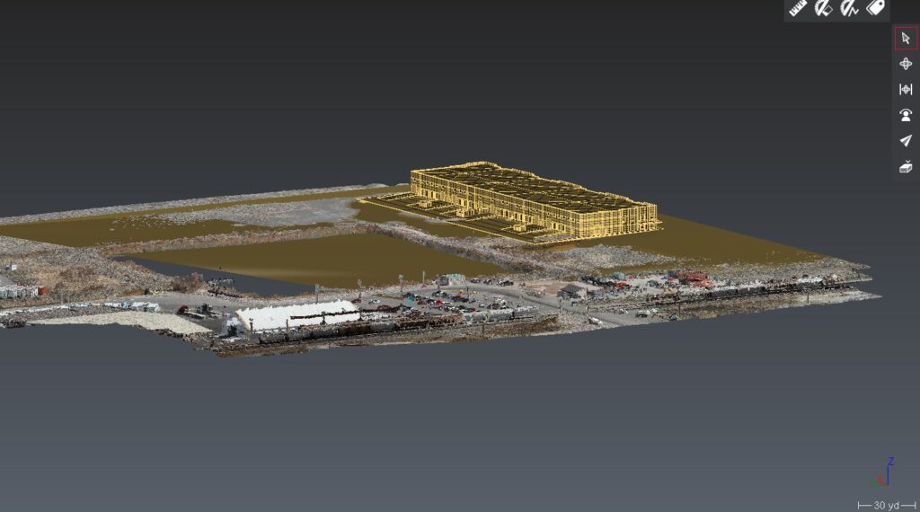
Drones and unmanned aircraft in AEC scanning and construction

Six ways drones have proven themselves as a tool for the AEC, Surveying, and mapping industries

Drones and unmanned aircraft in AEC scanning and construction process are becoming more common.  Unmanned aircraft, or drones are becoming much more common on today’s project sites. many companies in the AEC, Surveying and mapping industries are utilizing these aircraft daily. So how do drones capture data? What are professionals getting out of said data? What makes a drone into a valuable tool versus a toy?

UAS technology has advanced to a point where the aircraft; while still very sophisticated, are quite simple to operate. They utilize; altimeter’s, magnetometers, inertial measurement units, GNSS (GPS) and radio transmitters to control the flight operations, but the end-user would never know it. These sensors and more are all managed behind the scenes so well that an operator can takeoff from any point, fly a “mission” which involves several tasks collecting data, avoid collisions from unexpected obstacles, know when they have just enough battery to return home safely and land all in a constantly changing environment, 100% autonomously starting from a single tap for initiation. Flying a drone is fun but unless you’re collecting data it brings no value. There are many sensors that can be attached to unmanned aircraft such as LiDAR and Gravitometers but in this article we are primarily going to address cameras and their use in Photogrammetry.

Photogrammetry

When you photograph an object from two different angles and add some Trigonometry, three dimensional measurements can be calculated.  The entire process is simple and automated.  A 3D model from aerial imagery is nothing new. Photogrammetry can be summarized as; the art, science and technology of making precise measurements from photos, and has been around since the mid 1800’s.

The whole process works like this: The distance (f) from a Camera Lens to its sensor is proportional to the distance (h) from said camera lens to objects being photographed. This property is written into several equations that photogrammetrists use to calculate things such as the scale of a photo and even the elevation of specific points or pixels in aerial photographs.

When two overlapping photographs are in correct orientation relative to each other, a Stereopair or Stereoscopic Imagery exists.  This imagery creates perspective on objects within the overlap of the photographs and is the principle behind all forms of 3D viewing.

Stereoscopic Imagery drones and unmanned aircraft in AEC scanning and construction

As mentioned above, drone users can pre-program routes to fly over their intended mapping area. Photos are taken with specific overlap which is computed based on altitude, speed, and the resolution of their camera sensor. Drones use the onboard sensors like GNSS or even real time corrected positioning (RTK) to both georeference the photos taken, control the flight of the by changing the RPM’s of the individual motors. This data is all carried over in the image files where they are further processed.

Today’s Photogrammetry softwares use these mathematical principles to orient, scale and combine photographs and data. The software will ultimately generate Point Clouds, Orthorectified (measurable) photos and 3D models with varying output types.

Project Output drones and unmanned aircraft in AEC scanning and construction

Drones and unmanned aircraft in AEC and Construction:  Valuable Applications for AEC, Surveying, and mapping.

Surveying and Mapping. The use of drones and unmanned vehicles in surveying and mapping is almost self-evident. Surveyors and Cartographers have used Aerial Photography dating back about as far as the invention of the airplane. What may not be immediately apparent are the costs to purchase a survey-quality UAS and required software is a small investment in comparison to traditions surveying equipment and the man hours saved easily pays for itself.   Point Clouds and Orthometric photos are great for drafting planimetric features and generating TIN surfaces to represent topography. Whether you’re mapping for design data, a feasibility study, GIS, or performing an ALTA/ACSM survey, using unmanned vehicle to capture data may be significantly more efficient than traditional means.

Reality Capture, which is just that; capturing the reality of the current conditions of a project site. This is a great practice for design, bidding, marketing and simply helping clients “capture the vision.” This may be as simple as viewing an oblique photograph or as complicated as combining a designed structure with a 3D mesh and viewing it in VR. I personally get a kick whenever I see a IFC model inserted in a point cloud.

Building Information modeling (BIM). It would be hard to mention reality capture without mentioning BIM. While flying a drone indoors is doable its not very practical so this is not what we are referring to here. Many companies today, especially in the design-build world are utilizing BIM for much more than building modeling. They are integrating models in all their civil design as well.  These departments are already using laser scanning and are familiar with point clouds so adding a UAS into their tool chest is a natural move. Drones are great for capturing data that can be used for clash detection, QC, and as-built drawings.

Pre-Construction and Takeoffs are a major part of heavy civil construction. When it comes to moving dirt, knowing exactly what must be done can make all the difference in winning a bid, making a profit or losing your shorts. This is done when companies are bidding on projects, but the same process occurs over often in design builds and any time a RFI or change order comes up. Capturing data to that represent the existing site condition is key when building a model and matching existing roadway and other civil tie-in points. Using a drone is a great way to make this happen.

Project Output2 drones and unmanned aircraft in AEC scanning and construction

Project Management. Unmanned Aircraft may be utilized for many processes in project management. Creating progress reports and viewing current conditions may be the most basic use and might just be the most beneficial when it comes to decision making. Billing on some projects is solely based on materials moved and/or installed. This makes tracking linear feet, area, and volumes the bottom line. Some other overlooked uses may include, creating safety plans and incident reports, public involvement, and training. There are also various other project management uses above.

Inspections. Drones are one of the best tools utilized in inspections. Often an environment is not safe for a person such as inspecting a high wall in an open pit mine; or the situation may not be as efficient for an individual such as climbing versus flying to inspect bolts on a suspension bridge. When we apply the use of Infrared /thermals sensors to unmanned aircraft they are capably much more. Infrared light is absorbed by water making it possible to discover moisture that may be invisible to the naked eye. This is great for leak detection among other things. Thermal makes it possible to view and analyze heat signatures. This is often used to find areas of heat loss in anything from mechanical to thermal applications.

One of the biggest challenges today’s companies in the AEC, Surveying and Mapping industry face is a shortage of manpower. The only way to overcome a shortage in manpower is to innovate. Many choosing to innovate are looking to drone to solve their problems. Two trends I’ve noticed in helping companies develop their UAS applications is that they may start with a particular expectation in mind and one drone, but they always utilize their UAS data more than they anticipated and want to expand their drone fleet. I believe UAS technology is one of the best investments for a company in these industries to make. It is very apparent to me that Unmanned Aircraft are a major focus in developing technology. They are a powerful tool and not a toy.

By Bryan Worthen Kuker-Ranken SLC

Examples:
https://cloud.pix4d.com/dataset/812780/map?shareToken=30b94ff7-79a2-46e9-822e-0a97dbd26408

https://cloud.pix4d.com/dataset/788626/map?shareToken=38540ee0-e5a4-47e4-ab1a-6fb57ac48142
https://cloud.pix4d.com/dataset/665273/model?shareToken=612c5c7f-e47c-4721-8c2f-53ba80a6e544

Kuker-Ranken has been in business for nearly 100 years; Customer Service is our top priority, whether precision instruments, unmanned aircraft/drones, or construction support supplies.
Call us today for pricing on drones, training, and service! (800) 454-1310