


- The Year of LiDAR
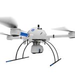 2022 is clearly the year of LiDAR. At all of the UAS shows in the USA, Mexico, Canada, and EU, the hot topic is LiDAR in 2022, and 2023 is ramping up to be more of the same, with significant growth. LiDAR is a “LIght Detection And Ranging” sensor, utilizing a laser, position-controlled mirror, an IMU (Inertial Measurement Unit) and internal processing to record geolocation data. A LiDAR sensor emits a… Read more: The Year of LiDAR
 - CONTROLLABILITY CHECKS REQUIRED FOR UAS FLIGHTWhether flying for the jobsite or flying for fun and family enjoyment, safety is always paramount with UAS (drones). There are the Federal Aviation Administration (FAA) regulations, also known as the FARs, and then there are the “Common-Sense” operational actions that all pilots, regardless of why the drone is flying, should be enacting prior to every flight. Pre-flight checks aren’t just good practice; they are required by federal law under Part… Read more: CONTROLLABILITY CHECKS REQUIRED FOR UAS FLIGHT
- 3 Months FREE PROCESSINGTHREE MONTHS FREE PROCESSING! Purchase a Microdrones MD1000HR between today and May 27, 2022, and save nearly $4000.00 in processing costs. When a Microdrones MD1000HR is purchased, customers typically purchase one year of limited access data processing. However, for this limited time, KR and Microdrones are offering three free months of unlimited processing, until May 27, 2022.We have units available now, so no need to wait! The MD1000HR flies over the… Read more: 3 Months FREE PROCESSING
- KR Blog!
- RTK CAPABLE DRONES/UAS for SURVEY, CONSTRUCTION, ENGINEERING
 SAVE TIME, GENERATE GREATER REVENUE WITH AERIAL TECHNOLOGY Real-Time Kinematic (RTK) corrections bring significant precision to unmanned aircraft and workflows, even to the point of achieving repeatable precision within 1cm of actual position in a localized dataset. Adding RTK to an unmanned aircraft enables real-time correctional data to be sent to the aircraft, allowing the aircraft to write corrected information to the metadata captured in the aircraft’s camera/sensor system. This is… Read more: RTK CAPABLE DRONES/UAS for SURVEY, CONSTRUCTION, ENGINEERING
 - Viva Las Vegas (LiDAR Excitement)
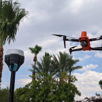
 Commercial UAV Expo effervesces in LiDAR and Face to Face gathering DR. A. STEWART WALKER 09.22.2021 Diversified Communications is the very model of a modern conference company, but even its most experienced managers must have harbored slivers of doubt as they prepared the Commercial UAV Expo Americas, in the Mirage, Las Vegas, on 7-9 September. If we make it, will they come? Will they be so desirous of renewed face-to-face contact… Read more: Viva Las Vegas (LiDAR Excitement)
 - A Deep Insider’s Look at a Rugged Terrain Mission to Investigate a Helicopter Crash with Drones
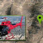 nce that may have not been seen for various reasons during a site walk-through.
 - LUTS, Log, 10Bit: Geeking Out on Camera Formats for Drones
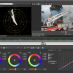 LUTS, Log, 10Bit: Geeking Out on Camera Formats for Drones It takes more than just a Part 107 to be a good drone service provider: customers require expertise in production, too. If you’re confused about camera formats for drones and some of the newest options on the market, we’ve got you covered with this deep dive. UAS expert and industry figure Douglas Spotted Eagle here at KukerRanken provides a detailed and expert… Read more: LUTS, Log, 10Bit: Geeking Out on Camera Formats for Drones
 - Does the Drone Industry Really Need 8K
 We have to roughly quadruplemegapixels to doubleresolution, so the jump from SD to HD makes sense, while the jump from HD to UHD/4K makes even more sense. Following that theme, jumping to 6K makes sense, while jumping to 8K is perfect theory, and nears the maximum of the human eye’s ability to resolve information.
 - Experts Tested 4 Different Drone Mapping Solutions for Crime Scene Investigation
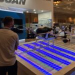
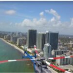
 Experts Tested 4 Different Drone Mapping Solutions for Crime Scene Investigation. Here’s What Happened. At Commercial UAV Expo in Las Vegas, more than 300 drone industry professionals watched as experts tested four different drone mapping solutions for crime scene investigation at night. Guest post by Douglas Spotted Eagle, Chief Strategy Officer at KukerRanken Commercial UAV Expo brought UAS professionals, developers, manufacturers, first responders, and related industries under one roof for the first time… Read more: Experts Tested 4 Different Drone Mapping Solutions for Crime Scene Investigation
 - Selecting the Right Drone for Your Construction Business
 Unmanned Aircraft (UA/Drones) have rapidly become a significant component of the modern construction industry workflow whether it’s for progress reporting, site planning, BIM, inventory control, safety awareness, structure inspection, topo’s, or other purposes. Site supervisors, architects, and stakeholders all benefit from the rapid output of accurate 2D/Ortho, or 3D models that may be used for purposes ranging from simple visualizations, progress reporting, stockpile calculations, DSM, contours, to more complex overlaying blue-prints in the As-Designed/As-Built or BIM process.
 - Part 91, 101, 103, 105, 107, 137: WHAT’S THE DIFFERENCE?
 All these FARs, what’s a drone pilot to do in order to understand them? Do they matter? YES! In virtually every aviation pursuit except for sUAS, an understanding of regulations is requisite and part of most testing mechanisms. As a result, many sUAS pilots holding a Remote Pilot Certificate under Part §107 are woefully uninformed, to the detriment of the industry. Therefore, sUAS pilots would be well-served to inform themselves of… Read more: Part 91, 101, 103, 105, 107, 137: WHAT’S THE DIFFERENCE?
 - Six ways drones have proven themselves as a tool for the AEC, Surveying, and mapping industries.
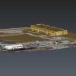 Drones and unmanned aircraft in AEC scanning and construction Six ways drones have proven themselves as a tool for the AEC, Surveying, and mapping industries Drones and unmanned aircraft in AEC scanning and construction process are becoming more common. Unmanned aircraft, or drones are becoming much more common on today’s project sites. many companies in the AEC, Surveying and mapping industries are utilizing these aircraft daily. So how do drones capture… Read more: Six ways drones have proven themselves as a tool for the AEC, Surveying, and mapping industries.