Experts Tested 4 Different Drone Mapping Solutions for Crime Scene Investigation. Here’s What Happened.
At Commercial UAV Expo in Las Vegas, more than 300 drone industry professionals watched as experts tested four different drone mapping solutions for crime scene investigation at night.
Guest post by Douglas Spotted Eagle, Chief Strategy Officer at KukerRanken
Commercial UAV Expo brought UAS professionals, developers, manufacturers, first responders, and related industries under one roof for the first time in nearly two years. Due to the pandemic, the show was less attended than previous years, yet provided robust live demonstrations, night flight, daytime seminars, panels, and case studies for the relatively large audience. There was a strong buzz amongst the crowd about being at an in-person event, and experiencing face to face communication for the first time in many months.
In addition to the “Beyond the Cage” Live Drone Demo Day that launched Commercial UAV 2021, produced by Sundance Media Group, Wednesday night provided attendees with a glimpse of the Crime Scene Investigator tools function in the dark hours. Sundance Media Group developed this methodology several years ago at the request of a law enforcement agency and has been presenting this methodology at academies, colleges, universities, and tradeshows since 2017, with a variety of aircraft including DJI Mavic, Phantom 4, Yuneec H520, Skydio, and Autel EVO series (versions 1 and 2). All successfully output data, excepting Skydio, which struggles with brightly lit events in surrounding darkness.

Presented by FoxFury, Sundance Media Group, Autel, and Pix4D, this event also invited SkyeBrowse to participate in the demonstration, showing the effectiveness and speed of their application.
Testing Drone Mapping Solutions for Crime Scene Investigation: Setting the Scene
With a model covered in moulage, mock slit throat, and blood trail on the ground, the demonstration began with the multi-vendor team led by Brady Reisch, Bryan Worthen of Kuker-Ranken, Todd Henderson and Patrick Harris of SMG, and David Martel. The team placed four FoxFury T56 lighting systems at specific, measured points in the scene, supplemented by FoxFury NOW lanterns and Rugo lighting to fill in holes and eliminate shadows.
Douglas Spotted Eagle of SMG and KukerRanken emcee’d the event through the two flights.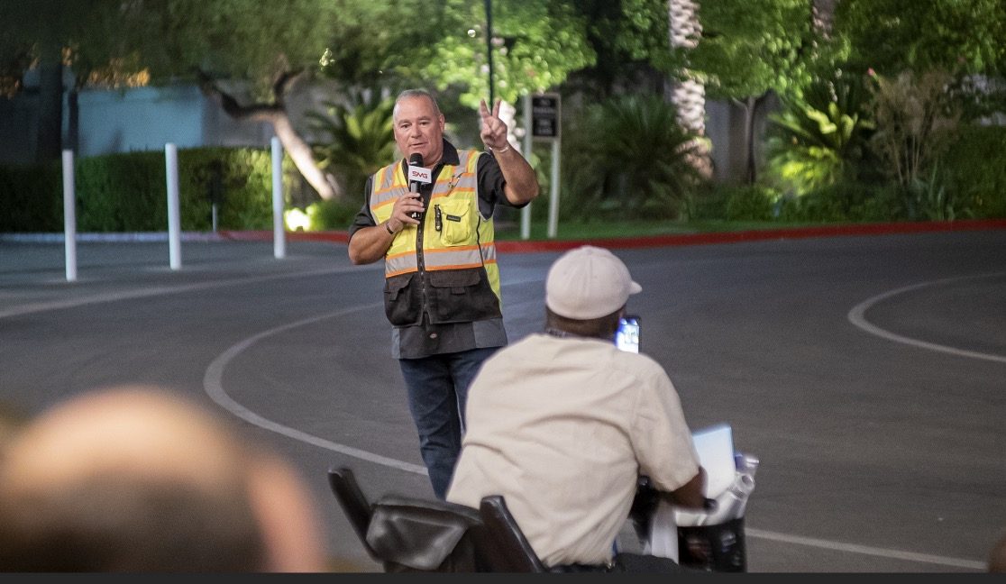
Douglas Spotted Eagle addresses the crowd of 300 persons
SkyeBrowse had the first flight, with its one-button capture. Brady Reisch set up the mission, with input from the SkyeBrowse developer instructing the exposure levels of the camera for the SkyeBrowse video mission. Once the mission was completed, the photos were uploaded to the SkyeBrowse website, where results were found approximately 30 minutes following the flight.
Brady Reisch of KukerRanken sets up the Skybrowse mission with Bobby Ouyang of Skybrowse
The Autel EVO II Pro was programmed on-site for an automated Skybrowse mission and the demonstration began. The area is highly congested with palm trees and buildings enclosing the small rotunda in front of the Mirage Hotel Convention Center.

Brady Reisch flew the second EVO II mission manually, in much the same configuration as though the aircraft had flown a double-grid mission, supplemented by high-altitude orbit, coupled with manually captured orbit and select placements. Because of the crowd, time was a consideration. In an actual homicide scene, more low-placed images would have been captured.

Brady Reisch monitors time as Pix4DReact rapid-renders the scene (60 seconds)
The mission photos were uploaded to Pix4dReact on-scene and rendered while the audience observed, requiring approximately 60 seconds to output an ortho-rectified, 2D image, complete with evidence markers/tags, and PDF supplemental report output. Also loaded were the photo images into Pix4D and Leica Infinity software packages, to be rendered for 3D viewing once the show floor opened on Thursday. Pix4DReact is a two-dimensional, rapid-mapping solution, so there is no 3D view.
The four screen captures tell the rest of the story, and readers can determine for themselves what each software is capable of providing. One point of interest is that there were many claims of “guaranteed 1cm of precision regardless of flight area,” which has yet to be verified. The Kuker-Ranken team will be re-flying a mission with two separate GPS systems (Leica and Emlid) to verify the claims of precision.
Precision is Repeatable
Precision is repeatable. Accuracy is the degree of closeness to true value. Precision is the degree to which an instrument or process will repeat the same value. In other words, accuracy is the degree of veracity while precision is the degree of reproducibility. With a base station, NTRIP, Spydernet, PPK, or RTK workflow, precision is always the goal, well-beyond accuracy. This is a relatively new discussion in the use of unmanned aircraft, and although the topic seems simple enough, complexity holds challenges not easily dismissed by inexperience or lacking education and practice. We are fortunate to have a partner in Kuker-Ranken, providing precision tools to the survey, forensic, civil engineering, and AEC industries since 1928. The KR team includes PLS’, EIT, and other accredited precision professionals, rarely found in the UAS industry.
Precision is critical for surveyors, civil engineers, forensic analysts and investigators, construction sites, mapping, agriculture, and other verticals in the UAS industry, and this sort of scene is no exception. Being able to properly place a map or model into a coordinate is necessary for many professional pilots in the UAV field, and while this mission is not precise to coordinate, it is precise within itself, or in other words, measurements will be accurate in the image, while being imprecise to the overall location.
We’ll dive more deeply into precision in a future article. For purposes of this exercise, we’re more interested in accuracy of content in the scene, and all four outputs were similar in accuracy within the scene itself. In other words, distances, volumes, and angles may be measured point to point. Pix4DReact is not as accurate as the other three tools, as it’s not intended to be a deeply accurate application given speed of output.
Output Results of Drone Mapping Solutions
Output #1: SkyeBrowse (processing time, approximately 35 minutes)
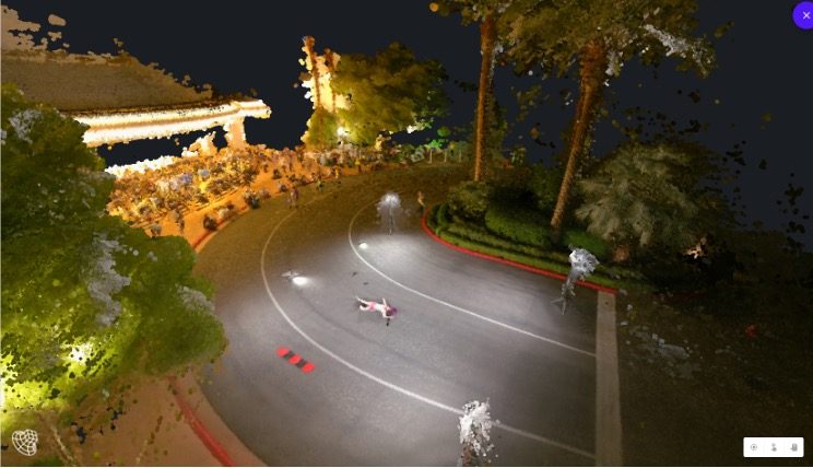
Output #2: Pix4Dreact (processing time, approximately 1 minute)
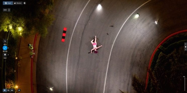
Output #3: Pix4Dmapper (processing time, approximately 2.5 hours)
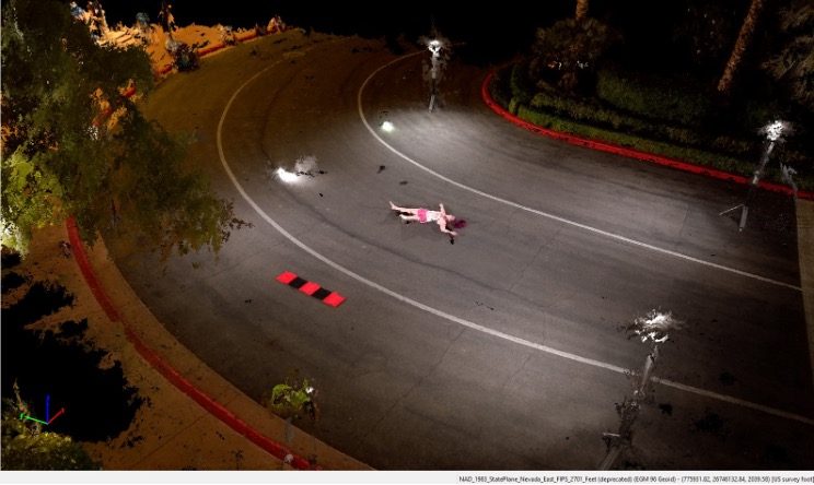
Output #4: Leica Infinity (processing time, approximately 2 hours, 50 minutes)
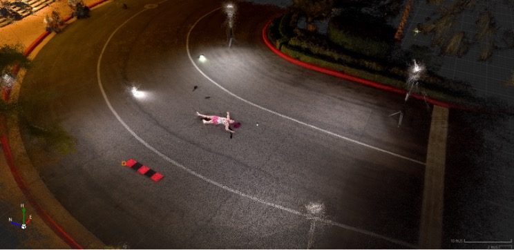
Agencies who would like access to this data are invited to contact Brady Reisch, VDC Specialist at Kuker-Ranken.


